Overview: This leg of the West Coast adventure takes a southerly turn, heading towards one of Oregon’s most iconic natural wonders: Crater Lake National Park. The journey includes stops at impressive waterfalls like Salt Creek Falls and viewpoints such as Spencer Butte. The exploration of Crater Lake involves learning about its cataclysmic formation, attempting snowy hikes to panoramic vistas like Garfield Peak and Watchman Lookout, and experiencing its profound beauty. The route then crosses back into California, visiting unique spots like a towering flagpole and venturing onto the slopes of Mount Shasta, before concluding with explorations in Lassen Volcanic National Park and the Sierra Buttes. This post details these encounters with Oregon’s deepest lake and California’s volcanic and alpine landscapes.
Day 13 (Continued): Thursday, May 29th, 2025 – Waterfalls, Buttes, and the Road South
- Key Locations Visited: Salt Creek Falls, Detroit (Oregon), Spencer Butte Summit (near Eugene).
- Activities: Waterfall viewing, scenic driving, hiking Spencer Butte.
- Overnight Location: Rest area (slept in car).
After the visit to Sahalie Falls, the journey continued southward. The next significant stop was Salt Creek Falls.
Deep Dive: Salt Creek Falls
- Height and Formation: At 286 feet (87 meters), Salt Creek Falls is Oregon’s second-highest single-drop waterfall (after Multnomah Falls, which is tiered). It’s a powerful plunge waterfall where Salt Creek, a tributary of the Willamette River, cascades over a rugged, amphitheater-like cliff formed by ancient lava flows.
- Location and Accessibility: Located in the Willamette National Forest, easily accessible from Highway 58. A paved, wheelchair-accessible trail leads from the parking lot to an excellent viewpoint overlooking the falls. Further trails, like the Diamond Creek Falls Loop Trail, offer more extensive hiking opportunities in the area, leading to other waterfalls and through old-growth forest.
- Seasonal Flow: The falls are impressive year-round, but flow is typically strongest in spring and early summer due to snowmelt. In winter, the area can be a popular spot for snowshoeing and cross-country skiing, with the falls sometimes partially frozen.
A stop was also made in Detroit, Oregon. This small town is situated on the shores of Detroit Lake, a reservoir on the North Santiam River popular for boating, fishing, and camping. The area has unfortunately been significantly impacted by wildfires in recent years, including the devastating Labor Day fires of 2020, and is in a process of recovery and rebuilding.
Later in the day, the route led to Spencer Butte near Eugene for a hike to its summit.
Deep Dive: Spencer Butte
- Prominent Landmark: Located just south of Eugene, Spencer Butte is a prominent landmark rising to an elevation of 2,058 feet (627 meters). It’s a popular recreational area for locals and visitors.
- Geology: The Butte is composed of basaltic andesite, a type of volcanic rock, dating back to the Eocene epoch (around 30-40 million years ago).
- Hiking Trails: Several trails lead to the summit, varying in difficulty. The main trail is about 1.7 miles round trip.
- Summit Views: The summit offers panoramic 360-degree views of Eugene, Springfield, the Willamette Valley, the Cascade Mountains to the east (including the Three Sisters on clear days), and the Coast Range to the west. It’s a particularly popular spot for sunset views.
The views from Spencer Butte summit were indeed impressive, offering a broad perspective over the surrounding landscape. That night, a rest area provided a more comfortable night’s sleep in the car.


Day 14: Friday – Journey to Crater Lake: Deepest Blue
- Key Locations Visited: Creek Falls Trailhead (likely a misremembered name, possibly Toketee Falls or a smaller trail near Crater Lake), Crater Lake National Park (Entrance Station, Rim Village Visitor Center, Garfield Peak Trail (partial hike), Discovery Point, Watchman Overlook (hike attempt)).
- Activities: Driving, attempting hikes in snowy conditions, watching the park film.
- Overnight Location: Hostel in Ashland.
The journey continued towards Crater Lake National Park. A stop was made at what was recalled as “Creek Falls Trailhead.” (This might refer to nearby Toketee Falls, a very popular and beautiful tiered waterfall on the North Umpqua River, or another smaller trail in the Umpqua National Forest leading to a waterfall, as “Creek Falls” isn’t a prominent named feature in that immediate area).
Upon reaching the entrance station of Crater Lake National Park, an attempt to use a video of a National Park Pass (forgotten at home) was unfortunately, and understandably, not accepted by the ranger. The standard entrance fee of $30 was paid.
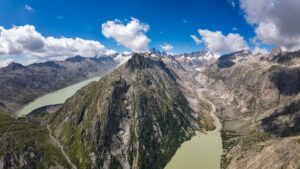
Deep Dive: Crater Lake National Park
- Formation – The Cataclysm of Mount Mazama:
- Ancient Mountain: Crater Lake occupies the caldera of Mount Mazama, a massive stratovolcano that was once part of the Cascade Volcanic Arc. Geologists estimate Mount Mazama stood around 12,000 feet (3,660 meters) tall before its climactic eruption. For comparison, Mount Hood is 11,249 feet.
- The Eruption: Approximately 7,700 years ago, Mount Mazama erupted violently over a period of days or weeks, expelling an enormous volume of magma (estimated at 12 cubic miles). This emptied the magma chamber beneath the mountain.
- Caldera Collapse: With its underlying support gone, the summit of Mount Mazama collapsed inward, forming a large, deep caldera approximately 5-6 miles (8-10 km) in diameter and up to 4,000 feet (1,220 meters) deep.
- Lake Formation: Over centuries, rain and snowmelt gradually filled the caldera, forming Crater Lake. There are no rivers or streams flowing into or out of the lake, so its water is exceptionally pure and clear, primarily lost through evaporation and seepage.
- Deepest Lake in the USA: With a maximum measured depth of 1,949 feet (594 meters), Crater Lake is the deepest lake in the United States and the ninth deepest in the world.
- Size Comparison (Lake Zug, Switzerland): Lake Zug has a maximum depth of 198 meters (650 feet) and a surface area of about 38.41 km². Crater Lake has a surface area of about 53 km² (20.6 sq mi) and is nearly three times deeper.
- Cultural Significance: The lake and surrounding area hold deep spiritual significance for Native American tribes, particularly the Klamath people, whose oral traditions include accounts of the cataclysmic eruption.
- National Park Status: Established in 1902, it is the fifth oldest national park in the United States and the only national park in Oregon.
The first stop within the park was the Rim Village Visitor Center. An attempt to buy postage stamps was thwarted by long queues. Instead, the park’s interpretive film was viewed, which vividly explained the lake’s dramatic geological history.
Following the film, a hike was attempted towards Garfield Peak. However, significant snowpack still covered the trail. About halfway up, the decision was made to stop and enjoy the view, as further progress without more specialized snow gear would have been difficult. It was noted that most other visitors were not attempting this snowy section, likely due to inadequate footwear (sneakers vs. sturdy, crampon-compatible boots which were worn and effective in the conditions).
Next, an attempt was made to reach Watchman Overlook by car, but the road was closed at Discovery Point due to snow. Parking at Discovery Point, the journey to Watchman Overlook was undertaken on foot, walking relatively directly through the snow to the summit. For about an hour, the viewpoint was enjoyed in solitude. Surprisingly, a couple then arrived, who, it turned out, were also electrical engineers, leading to an enjoyable and interesting conversation during the shared descent.
Deep Dive: Key Features in Crater Lake National Park (Rim Drive)
- Rim Drive: A 33-mile (53 km) scenic road that circles the caldera, offering numerous overlooks and trailheads. It’s typically open from July to October, weather permitting, though sections (especially the West Rim Drive to Discovery Point and Rim Village) often open earlier.
- Garfield Peak Trail: A popular, moderately strenuous 1.7-mile (one way) trail from Rim Village, offering panoramic views of the lake, Wizard Island, and Phantom Ship.
- Discovery Point: One of the first places from which early explorers “discovered” (from a Euro-American perspective) the lake. Offers classic views.
- Watchman Peak & Lookout: The Watchman Peak Trail (0.8 miles one way, strenuous) leads to a historic fire lookout (built 1932) on Watchman Peak, offering some of the best sunset views over the lake. It’s often one of the last sections of Rim Drive to open due to snow.
- Wizard Island: A volcanic cone formed by eruptions within the caldera after the main collapse of Mount Mazama. Boat tours (summer only) take visitors to the island, where one can hike to the summit.
- Phantom Ship: A small, craggy island resembling a sailing ship, composed of older, erosion-resistant andesite lava.
The day concluded with a drive to Ashland, Oregon, a city known for the Oregon Shakespeare Festival. Accommodation was at a very nice hostel, sharing a 4-person room with only one other person – an interesting individual who had lived for several years in Kyrgyzstan, Kazakhstan, Russia, and China, and shared fascinating experiences. Laundry was also done, a necessity after several days of hiking. Bedtime was around 11:30 PM.


Day 15: Saturday – California Return: Flagpoles, Shasta Slopes, and Sunset Views
- Key Locations Visited: World’s Tallest Flagpole (Sheldon Inn, CA – likely a misidentification, the actual record holder is elsewhere, but a very tall one was visited), Mount Shasta (Bunny Flat Trailhead, hike towards Horse Camp/Avalanche Gulch), Hat Creek Rim Scenic Viewpoint.
- Activities: Visiting a tall flagpole, hiking on Mount Shasta’s slopes, sunset viewing.
- Overnight Location: Forest road near Hat Creek Rim (slept in car).
The morning began with a drive south, crossing back into California. A stop was made to see what was believed to be the “second largest flagpole in the States” at 200 feet tall. (While impressive, the record for the tallest flagpole in the US is significantly higher and located elsewhere, e.g., Sheboygan, Wisconsin, often has a contender. The specific location visited near Sheldon, CA, likely hosts a very tall, notable flagpole, but not a record holder of that rank).
The journey then continued to Mount Shasta. The access road to higher trailheads was not fully open due to snow, so the car was parked at a lower elevation (likely Bunny Flat Trailhead, a common starting point at around 6,950 feet). From there, a random hike was undertaken up the snow-covered slopes, eventually reaching a point above the treeline at approximately 3,000 meters (around 9,800 feet). The views from this elevation were once again spectacular.
Deep Dive: Mount Shasta
- Majestic Volcano: A massive, potentially active stratovolcano in the Cascade Range, Mount Shasta is the second-highest peak in the Cascades (after Mount Rainier) and the fifth-highest in California, with an elevation of 14,179 feet (4,322 meters).
- Geology: Composed of multiple overlapping volcanic cones, Shasta has erupted periodically for hundreds of thousands of years. It’s known for its immense bulk and prominent glaciers (though these are receding).
- Spiritual Significance: Mount Shasta is considered a sacred site by various Native American tribes and is also a focus for many New Age and spiritual beliefs, often associated with esoteric legends and energy vortexes.
- Recreation: A major destination for mountaineering (various routes to the summit, typically requiring ice axe and crampons), backcountry skiing, hiking, and camping. Popular trailheads include Bunny Flat (for Avalanche Gulch route), Northgate, and Clear Creek. Horse Camp is a common staging area/shelter on the Avalanche Gulch route.
- Road Access: The Everett Memorial Highway provides paved access to Bunny Flat and the Old Ski Bowl area, but higher sections can remain snowbound well into summer.
For the evening, the Hat Creek Rim Scenic Viewpoint was chosen as the destination, with the intention of seeing both sunset and sunrise. Overnight parking is not permitted directly at the viewpoint, so a nearby forest road provided a secluded spot for the car.


Deep Dive: Hat Creek Rim
- Location & Geology: Part of the Modoc Plateau, Hat Creek Rim is a prominent escarpment overlooking the Hat Creek Valley. It’s formed by a large basaltic lava flow.
- Scenic Viewpoint: Offers expansive views east across the valley towards the Warner Mountains and the Great Basin. It’s particularly known for its dark skies, making it a good spot for stargazing. The Pacific Crest Trail (PCT) traverses this rim.
Day 16: Sunday – Lassen’s Volcanic Wonders and Sierra Buttes Ascent
- Key Locations Visited: Hat Creek Rim (sunrise), Lassen Volcanic National Park (North Entrance, Manzanita Lake area), Sierra Buttes Lookout.
- Activities: Sunrise viewing, scenic driving through Lassen (limited access), hiking to Sierra Buttes Lookout.
- Overnight Location: Hostel in Sacramento.
After witnessing the sunrise from the Hat Creek Rim area (which, like the sunset, was not among the most spectacular of the trip), the journey continued to Lassen Volcanic National Park. Entry was made via the north entrance.
Deep Dive: Lassen Volcanic National Park
- Volcanic Landscape: The park showcases all four types of volcanoes found in the world (shield, composite/stratovolcano, cinder cone, and plug dome). It’s centered around Lassen Peak, the largest plug dome volcano in the world, which last erupted between 1914 and 1917.
- Hydrothermal Features: Known for its active hydrothermal areas, including boiling mud pots, steaming fumaroles, and sulfur vents (e.g., Bumpass Hell, Sulphur Works).
- Seasonal Access: Much of the main park road (Lassen Volcanic National Park Highway) is typically closed from November to May or June due to heavy snowfall (the park receives some of the highest snowfall totals in California). Access during early season is often limited to areas around Manzanita Lake (north entrance) and the Kohm Yah-mah-nee Visitor Center (south entrance).
On this visit, the park road was still mostly closed due to snow. The north entrance area around Manzanita Lake, while scenic, was heavily snow-covered, limiting exploration. Due to this, the south entrance was skipped, and the journey proceeded directly to the next stop: Sierra Buttes.
Part of the road to the Sierra Buttes trailhead was also snow-covered, necessitating a slightly longer walk than the normal route. The hike to the Sierra Buttes Lookout was enjoyable, taking about 3 hours round trip.
Deep Dive: Sierra Buttes Lookout
- Prominent Peaks: The Sierra Buttes are a series of rugged granite peaks located in the Tahoe National Forest, with the highest point reaching 8,591 feet (2,619 meters).
- Fire Lookout: Perched dramatically atop the main butte is a historic fire lookout, accessible via a thrilling trail that includes steep metal staircases bolted to the rock face. The lookout was built in the early 20th century and offers breathtaking 360-degree views of the Northern Sierra Nevada, including Sardine Lakes below.
- Hiking: The hike to the lookout is strenuous but highly rewarding. The final ascent via the staircases is not for those with a fear of heights.
- Wildlife & Scenery: The area is known for its alpine scenery, wildflowers in summer, and opportunities to see wildlife.
During the descent, a group of other hikers was joined. Only one of them had made it to the very top of the lookout; the others, less experienced with snow and exposure, had opted to stay below the final snowfield crossing. Sturdy boots proved advantageous in navigating the snowy and loose terrain, whereas their sneakers offered less security.
Once down, a long drive led to Sacramento, where check-in at a downtown hostel was completed. The hostel was very nice, centrally located with available parking, and surprisingly uncrowded.


Day 17: Monday – Sacramento Exploration: History, Politics, and Drag Queens
- Key Locations Visited: Old Sacramento Waterfront, Stanley Mosk Library and Courts Building (and Judge’s Library), California State Capitol, a German restaurant, a bar with a drag show.
- Activities: City exploration, visiting historical and governmental buildings, unexpected cultural encounter.
- Overnight Location: Hostel in Sacramento.
The evening in Sacramento included a typical city walk, which took an unexpected turn upon entering a busy bar that happened to be hosting a drag show.
Deep Dive: Drag Shows
- Performance Art: A drag show is a form of entertainment where performers (drag queens or drag kings) impersonate and often satirize male or female gender stereotypes through elaborate costumes, makeup, and performance styles that can include singing (often lip-syncing), dancing, comedy, and audience interaction.
- Cultural Significance: Drag has a long and rich history within LGBTQ+ communities, often serving as a form of self-expression, community building, and social commentary. It has gained mainstream popularity in recent years through shows like RuPaul’s Drag Race.
This was a novel experience, involving conversations with various interesting and “strange” (in a fascinating way) people before returning to the hostel.
The following morning (Day 17) was dedicated to exploring Sacramento:
- Old Sacramento Waterfront: A historic district featuring preserved or reconstructed buildings from the Gold Rush era, cobblestone streets, museums (like the California State Railroad Museum), and riverboat cruises.
- Stanley Mosk Library and Courts Building: Home to the California State Library and the California Supreme Court and Court of Appeal. A chance encounter here with some people led to plans to meet later at a German restaurant.
- California State Capitol: The seat of California’s state government. A free tour was taken, which included the opportunity to observe a live legislative discussion.
- German Restaurant: The planned meet-up with the newly met acquaintances resulted in a pleasant 3-hour conversation. They kindly offered to pay for dinner, which was declined due to tiredness and a desire to write.
Bedtime was around 10:00 PM.


Day 18: Tuesday – The Long Drive Home: Car Wash Woes and LAX Return
- Route: Sacramento to Los Angeles International Airport (LAX).
- Activities: Long-distance driving, eventful car wash experience.
- Travel: Flight from LAX to Zürich.
An early 7:00 AM start preceded a scheduled 6-hour drive to LAX, which ultimately took longer due to stops for food, gas, and a car wash.
The car wash experience, at an attended station costing around $12, was eventful. Unfamiliar with the procedure and missing the sign to put the car in neutral, the washing machinery had to be stopped. A second stoppage occurred because the car’s auto-hold brake feature was still engaged. After these issues were resolved, the car went through, but emerged not particularly clean and with a bent license plate. The staff allowed a second pass after some machine adjustments, which cleaned the car better but bent the plate again. The plate was manually bent back into shape. The car was also vacuumed thoroughly, partly due to a previous negative experience with a rental car return (OK Car Rental in Tarifa, Spain, being strict about cleanliness) and partly because the current Hertz rental was extremely dirty from unpaved road driving (which is often prohibited by rental agreements) and had scratches from branches. The aim was to avoid scrutiny.
Arrival at LAX was around 4:00 PM, with heavy traffic already present. The Hertz car return was straightforward. An hour later, waiting at the gate commenced. The flight to Zürich did not have a window seat, but pleasant conversations were had with a Polish seatmate and an American girl for about an hour, until a passenger behind requested quieter conversation. Dinner was served, followed by sleep until breakfast. Landing in Zürich occurred 35 minutes after finishing breakfast. The flight time passed quickly, with surprisingly good sleep achieved on the plane. Arrival back home was around 5:00 AM.