Overview: This segment of the West Coast adventure marks the transition from California’s redwood coast into Oregon, a state immediately impressing with its even more rugged and wild shoreline. The journey includes encounters with unique coastal phenomena like expansive sand dunes juxtaposed with forests, leading to a thrilling off-road quad biking experience in the Oregon Dunes National Recreation Area. The drive continues north, punctuated by a scenic helicopter flight, before culminating in crossing the iconic Astoria-Megler Bridge into Washington state. The day concludes with a picturesque drive along the Columbia River to Portland, Oregon, complete with an unexpected fireworks display. This post offers detailed insights into these locations and activities.
Day 6 (previous post): Thursday – Oregon’s Call: Coastal Grandeur and Dune Adventures
- Route: North from Redwood National Park area (CA) into Oregon via US-101.
- Key Locations Visited: Oregon Coast (general), Meyers Beach (OR), Oregon Dunes National Recreation Area (near Florence/Coos Bay).
- Activities: Coastal driving, Quad biking with Dune Bugs/CMS (family business).
- Overnight Location: Public parking spot in a coastal village in Oregon.
The journey commenced early, leaving the redwood empire of Northern California and crossing into Oregon. Even the northernmost parts of California had begun to exude a more forested, Pacific Northwest ambiance, distinct from its southern character. Oregon amplified this sensation immediately. The coastline presented a raw, dramatic beauty that, in many aspects, felt even more untamed and impressive than California’s renowned shores.
An early stop was Meyers Beach, Oregon. This location, part of the Samuel H. Boardman State Scenic Corridor, is characteristic of the southern Oregon coast, known for its stunning sea stacks, secluded coves, and dramatic cliffs. The views compelled an immediate stop to absorb the rugged beauty.
Deep Dive: Meyers Beach & Samuel H. Boardman State Scenic Corridor
- Location: Situated along a 12-mile stretch of US-101 in Curry County, just north of Brookings, Oregon.
- Features: This corridor is famed for its steep, forested headlands dropping to the Pacific, interspersed with small sandy beaches and numerous offshore sea stacks and islands like those visible at Meyers Beach (often including “Kissing Rock”). It offers numerous viewpoints and trailheads leading to breathtaking vistas and secluded beaches, such as Natural Bridges, Whaleshead Beach, and Indian Sands.
- Geology: The dramatic coastal formations are the result of millennia of erosion by wind and waves acting on the resilient rock of the Klamath Mountains.
Continuing north, the landscape presented a fascinating and unexpected phenomenon: vast sand dunes rising directly adjacent to, and in some cases intermingling with, dense coastal forests. This surreal juxtaposition of desert-like dunes and verdant woodland prompted a decision to explore the area more thoroughly. This led to the Oregon Dunes National Recreation Area.
While driving through this unique region, a rental shop named “Dune Bugs/CMS” (a family-run business) offered quad (ATV) rentals. The allure of exploring the dunes actively was irresistible. For $71, an hour-long quad rental was secured. After brief instructions, provision of a helmet and glasses, the adventure began.
Deep Dive: Oregon Dunes National Recreation Area
- Geography & Scale: Stretching approximately 40 miles along the Oregon coast from Florence in the north to Coos Bay in the south, this is one of the largest expanses of temperate coastal sand dunes in the world. Some dunes can reach heights of up to 500 feet above sea level.
- Formation: The dunes are primarily the product of erosion from the Oregon Coast Range mountains. Rivers like the Siuslaw and Umpqua carried sediments (sand and silt) to the ocean. Prevailing winds from the Pacific then transported this sand onshore, sculpting it into the vast dune system seen today. This process has been ongoing for thousands of years.
- Unique Ecosystems: The area is not just barren sand. It comprises a mosaic of distinct ecological zones:
- Beach: The interface with the ocean.
- Foredunes: The first line of dunes, often stabilized by vegetation like European beachgrass (an introduced species that has significantly altered dune dynamics).
- Deflation Plains: Lower-lying areas between dune ridges where the wind has scoured away sand, sometimes reaching the water table and forming wetlands or small lakes (as encountered on the quad ride).
- Transverse Dunes: Large, actively moving dunes perpendicular to the prevailing winds.
- Oblique Dunes & Parabolic Dunes: Other dune forms shaped by wind and vegetation.
- Inland Forests: Where the dunes meet the coastal Sitka spruce and shore pine forests.
- Recreation: Hugely popular for Off-Highway Vehicle (OHV) riding (ATVs, dune buggies, dirt bikes) in designated areas. Other activities include hiking (e.g., John Dellenback Dunes Trail, Umpqua Dunes Trail), fishing, camping, canoeing/kayaking on the interdunal lakes, and wildlife viewing.
- Management: Managed by the U.S. Forest Service (Siuslaw National Forest). There are visitor centers and staging areas providing information and access.
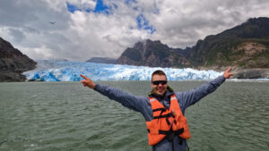
The initial encounter with a massive dune on the quad was exhilarating. Recalling the instructor’s advice – “straight up and straight down, full throttle to ascend” – the dune was successfully summited. While navigating, an instinctive motorcycle-riding habit of putting a leg out during a potential tip had to be consciously suppressed, as the weight of a quad could cause serious injury; the correct procedure is to dismount to the high side. The dune exploration revealed stunning interdunal lakes – a surreal landscape of sand, forest, lakes, and the ocean in the distance. The recommended coastal route was followed before returning the quad. This experience was a definite highlight of the trip so far.
After the quad adventure, the northward journey continued. The unique landscape of dunes bordering forests persisted, with many other tourists enjoying OHV activities. As sunset approached, a public parking spot in a small coastal village provided the overnight stop. Several other RVs were also present, and despite proximity to the road, it was a night of sound sleep.


Day 7: Friday – Helicopter Views, Bridging the Columbia, and Portland’s Welcome
- Route: North along the Oregon Coast (US-101), crossing the Astoria-Megler Bridge into Washington, then east along the Columbia River (WA-4 E / US-30 E) to Portland, Oregon.
- Key Locations Visited: Oregon Coast (various scenic stops), Astoria-Megler Bridge, Portland.
- Activities: Coastal driving, Helicopter flight, crossing into Washington State, night city hike in Portland to view fireworks.
- Overnight Location: Northwestern Hostel, Portland.
The day began with continued travel north along Oregon’s picturesque coastline. Proximity to Washington state, coupled with a recommendation to experience the Astoria-Megler Bridge, solidified the decision to cross state lines.
Along the way, various scenic beach stops were made. One such stop presented an opportunity for a helicopter flight. For $169, a roughly 20-minute flight offered aerial views of the coastline. While any helicopter flight is inherently exciting, and this was a first coastal flight experience, the quad biking adventure remained the preferred thrill. Mountain helicopter flights hold a greater personal appeal.
The approach to the Astoria-Megler Bridge was impressive. This engineering marvel spans the mouth of the Columbia River, connecting Astoria, Oregon, with Point Ellice, Washington. Its sheer length and height were striking.
Deep Dive: Astoria-Megler Bridge
- Engineering & Statistics: Opened in August 1966, this continuous truss bridge is 4.1 miles (6.58 km) long, making it the longest continuous truss bridge in North America. The main span is 1,232 feet long and provides 196 feet of vertical clearance for shipping. Its construction faced significant challenges due to the powerful currents of the Columbia River (averaging 7 knots), deep water (up to 80 feet), and harsh weather conditions, including winds up to 150 mph.
- Historical Significance: It replaced a decades-old ferry service and was the final link completing U.S. Route 101 between Olympia, Washington, and Los Angeles, California. Its construction was a major undertaking, costing $24 million at the time (equivalent to over $200 million today).
- Designer: Designed by William Adair Bugge, a prominent bridge engineer.
- Economic Impact: The bridge dramatically improved transportation and commerce for the region, facilitating easier access to coastal communities and resources. It’s a vital link in the Pacific Coast highway system.
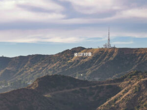
Once in Washington, the route turned eastward, following the scenic northern bank of the Columbia River towards Portland, Oregon. Upon arrival in Portland, accommodation was at the Northwestern Hostel, which proved to be a comfortable and well-regarded establishment.
A roommate in the 4-person shared room mentioned the possibility of fireworks that evening as part of the Portland Rose Festival.
Deep Dive: Portland Rose Festival
- Origins and History: This major annual civic festival dates back to 1907, conceived by Georgiana Pittock (wife of The Oregonian founder Henry Pittock) and community leaders to promote Portland as the “Summer Capital of the World.” The first festival included an electric parade with illuminated floats.
- Modern Festival: Today, it’s a multi-week event (typically late May to mid-June) featuring numerous activities:
- Grand Floral Parade: A centerpiece event with all-floral floats, marching bands, and equestrian units.
- Starlight Parade: An illuminated nighttime parade.
- CityFair: A carnival-like event at Tom McCall Waterfront Park with rides, food, and entertainment.
- Fleet Week: U.S. Navy, U.S. Coast Guard, and Royal Canadian Navy ships dock along the waterfront and are open for public tours.
- Rose Shows & Garden Contests: Celebrating the city’s floral heritage.
- Fireworks: Often mark key events within the festival.
- Significance: The festival is a significant cultural event for Portland, drawing hundreds of thousands of visitors and celebrating the city’s identity as the “City of Roses” (a nickname earned due to its ideal rose-growing climate, championed by early nurserymen and enthusiasts).
Intrigued, a two-hour night city hike was undertaken, culminating in a prime viewing spot. Indeed, at 9:50 PM, a spectacular 20-minute fireworks display erupted over the Willamette River, providing a vibrant welcome to Portland.
Back at the hostel, engaging conversations ensued with a fellow traveler from Florida motorbiking across the US, and later with an Indian and a Canadian traveler. Plans began to form with the latter two for potential joint explorations in the coming days. Next Post.