SPOT OVERVIEW
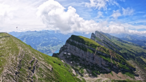
Marbachegg is nestled within the UNESCO Biosphere Entlebuch in Canton Lucerne. Facing the rugged, dramatic limestone karst crest of the Schrattenfluh, this flying arena combines majestic prealpine mountain scenery with versatile conditions for both thermal thermalling and dynamic soaring flights.
FLIGHT CHARACTERISTICS AND WIND
Marbachegg is an adaptable site that offers good shelter from mild alpine south foehn. It functions well under winds from northwest, west, north, and south directions. From late morning onward, sunlight warms the varied slopes and bowl topography, releasing reliable thermal updrafts along the ridges. Dynamic slope soaring can also be enjoyed along the plateau edge. Because the takeoff runway is relatively short before pitching downward, takeoffs in zero wind or light tailwind cycles require focused acceleration and clean wing inflation.
KEY FLIGHT PARAMETERS
- Primary Wind Directions: North West, West, North, and South
- Flight Type: Thermal soaring, plateau ridge lift, and panoramic scenic glides
- Best Season: Spring through autumn, with winter ski and fly operations also available
- Takeoff Altitude: 1480 meters above sea level
- Landing Altitude: Approximately 870 meters above sea level in Marbach
- Elevation Difference: 610 meters of vertical drop
- Pilot Level: Intermediate, due to short takeoff run and thermal activity near rock faces
- Local Club: Gleitschirmklub Amt Entlebuch (GSKAE) and Flugschule Marbach
FLIGHT IMPRESSIONS
LAUNCH SITE
The primary launch area is located just two minutes on foot from the mountain station of the Marbachegg gondola. The starting point is a grassy alpine knoll. Because the length of the takeoff slope is short, pilots should ensure their glider is cleanly centered overhead before running. In nil wind conditions, decisive forward running technique is essential.
LANDING SITE
There are two distinct landing options down in Marbach:
Landing Site near the Church (Laui): This spacious field is located slightly outside the village center and is highly recommended. It offers generous open dimensions, a straightforward approach pattern, and plenty of space for stress free flare and packing.
Landing Site near the Cable Car Valley Station: This alternative field sits southwest of the gondola station. It is tighter and bordered by buildings, trees, and terrain, demanding a more precise approach circuit.
AIRSPACE AND SAFETY
Airspace over the Marbach valley is uncomplicated, but pilots must respect local environmental regulations. Protected wildlife quiet zones exist around the Schrattenfluh massif, requiring pilots to maintain proper minimum clearance. Watch out for agricultural transport wires across lower pastures.
GETTING THERE AND ACCESS
Reach Marbach by car or regional PostBus through the Entlebuch valley. The Sportbahnen Marbachegg gondola operates regularly, taking pilots and their gear directly to the mountain ridge in a few minutes. Parking is available at the valley station.
USEFUL LINKS AND CLUB INFO
For up to date site reports, tandem bookings, and flight school details, visit the Flugschule Marbach and the Gleitschirmklub Amt Entlebuch online portal.