SPOT OVERVIEW
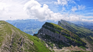
Emmetten Niederbauen is widely considered one of the premier paragliding destinations in Switzerland. Overlooking the turquoise waters of Lake Lucerne and framed by the dramatic limestone cliff amphitheater of Niederbauen Chulm, it offers breathtaking alpine vistas combined with exceptionally forgiving launch and flight conditions.
FLIGHT CHARACTERISTICS AND WIND
Niederbauen benefits from a sheltered microclimate that makes it flyable across many wind directions, including north, northwest, northeast, and south. On sunny days, a gentle thermodynamic breeze rises steadily up the mountain bowl, providing smooth inflation conditions on launch. Thermal sources trigger reliably along the sheer cliffs of Niederbauen, enabling pilots to gain thousands of meters and set off on cross country routes into the Uri Alps. Due to its popularity, sunny weekends can see lively queues at the aerial tramway. Flying in south foehn must be avoided.
KEY FLIGHT PARAMETERS
- Primary Wind Directions: North, North West, North East, and South
- Flight Type: Thermal soaring along the cliff faces, dynamic slope lift, and scenic cruising
- Best Season: March through November, with clear winter flights also popular
- Takeoff Altitude: 1570 meters above sea level at the mountain inn
- Landing Altitude: 750 meters above sea level at Emmetten
- Elevation Difference: 820 meters of vertical drop
- Pilot Level: Easy to intermediate, one of the most beginner friendly high takeoffs in Switzerland
- Local Club: Flugschule Emmetten and local pilot community
FLIGHT IMPRESSIONS
LAUNCH SITE
The primary launch area is located two minutes from the mountain station of the Niederbauen cable car, directly beside Berggasthaus Niederbauen. The takeoff is a vast, gently inclined alpine meadow that provides plenty of space for multiple gliders to inflate side by side. For hike and fly enthusiasts, a scenic mountain trail leads to the summit of Niederbauen Chulm at 1923 meters above sea level for a higher takeoff directly above the sheer north face.
LANDING SITE
The official landing field is located in Emmetten near the village school and sports area at roughly 750 meters above sea level. It is equipped with an official windsock and offers clear approach paths. Important note: The old landing meadow previously used near Restaurant Schlüssel is permanently closed and must not be used. Alternate landings exist in Seelisberg or along the lake shore at Beckenried.
AIRSPACE AND SAFETY
The main flight sector above Emmetten and Niederbauen sits outside the controlled airspace of the Buochs military airfield. However, descending out toward the lake landing in Beckenried enters the Buochs CTR. During military operating times on weekdays, flying into Beckenried requires radio clearance from Buochs Tower. Inspect the panorama boards at the valley station to take note of local transport cables.
GPS FOR CAR AND GETTING THERE
Drive along the A2 motorway exiting at Beckenried, then follow the road up to Emmetten. Park at the Egg cable car parking lot, where the Luftseilbahn Niederbauen takes pilots up to the mountain inn in about eight minutes.
USEFUL LINKS AND CLUB INFO
Flugschule Emmetten and Berggasthaus Niederbauen provide daily weather reports, webcam views, and local pilot guidance.