SPOT OVERVIEW
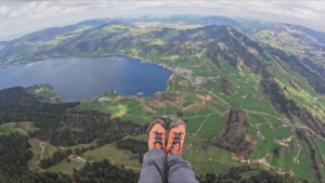
Rigi Scheidegg sits high on the eastern crest of Mount Rigi at approximately 1650 meters above sea level, representing the highest paragliding takeoff reachable by cable car on the Queen of the Mountains. Offering grand views over Lake Lucerne, Lake Lauerz, and the striking peaks of the Mythen, Rigi Scheidegg is a top tier destination for Central Swiss free flight enthusiasts.
FLIGHT CHARACTERISTICS AND WIND
Rigi Scheidegg is celebrated as an exceptional Bise (northeast wind) flying site. When steady eastern or northeastern winds sweep into Central Switzerland, the eastern slopes generate solid, laminar slope soaring. During spring and early summer, the steep rocky ribs below Scheidegg also produce active thermal currents that let pilots gain altitude rapidly. When the wind is light or absent, takeoffs require prompt, decisive running because the grassy runway is relatively short before sloping steeply downward.
KEY FLIGHT PARAMETERS
- Primary Wind Directions: North East (Bise), East, and North
- Flight Type: Bise ridge soaring, thermal climbing, and high altitude glides
- Best Season: March to October, excellent on sunny spring days with Bise
- Takeoff Altitude: 1650 meters above sea level
- Landing Altitude: 760 meters above sea level at Kräbel / Chräbel
- Elevation Difference: 890 meters of vertical drop
- Pilot Level: Intermediate, requires clean launch timing due to short takeoff meadow
- Local Club: Gleitschirmclub Rigi Mythen (GCRM)
FLIGHT IMPRESSIONS
LAUNCH SITE
The launch site is located two minutes from the Rigi Scheidegg cable car mountain station. The grassy slope faces toward the east and northeast. Because the runway length is short, pilots should wait for a clean headwind cycle and verify that the wing is completely stable above them before accelerating down the incline.
LANDING SITE
The primary landing field is situated at Chräbel (Kräbel), right beside the valley station of the Rigi Scheidegg cable car at around 760 meters above sea level. The approach requires careful circuit planning, as the field lies between the mountain slope and the railway lines. In strong valley wind conditions, pilots can also elect to continue their glide out to the broader fields near Goldau.
AIRSPACE AND SAFETY
Mount Rigi borders the control zones of military airfields at Emmen and Buochs. Always consult the official Gleitschirmclub Rigi Mythen flight boards to ensure you stay clear of active airspace sectors. Flying in south foehn is strictly prohibited due to severe turbulence and collapse hazards.
GETTING THERE AND ACCESS
Travel by car or train to Arth Goldau, and proceed to the Kräbel valley station. The modern Kräbel Rigi Scheidegg cable car whisks pilots up to the summit ridge in about six minutes. Ample paid parking is provided right at the valley station.
USEFUL LINKS AND CLUB INFO
The flying sites across Rigi are managed by the Gleitschirmclub Rigi Mythen (GCRM). Check their website for current notices, webcam links, and regional weather stations before heading out.